|
Home Back In Russian Alans-Contents |
Sources Roots Tamgas Alphabet Writing Language |
Genetics Geography Archeology Religion Coins Wikipedia |
Alans and Ases Scythians Kipchaks Alanian Etymology Notes Overview of Sarmatian chronology |
Ogur and Oguz Saltovo-Mayak Culture Codex of Inscriptions-Euro Asiatic-Don Alans in Pyrenees Zelenchuk Inscription |
Alan Dateline Avar Dateline Besenyo Dateline Bulgar Dateline Huns Dateline Karluk Dateline |
Khazar Dateline Kimak Dateline Kipchak Dateline Kyrgyz Dateline Sabir Dateline Seyanto Dateline |
|
Gennadii E. Afanas'ev, Maxim R. Zot'ko and Dimitrii S. Korobov Department of Rescue Archaeology - 19, Dm. Ulyanova Str. - 117036, Moscow, Russia The Experience of Application of Aerospace Probing Methods in the Study of Mayak Settlement(Edited excerpts from the summary, with minor spelling corrections) |
||||||
|
Links |
||||||
|
|
||||||
|
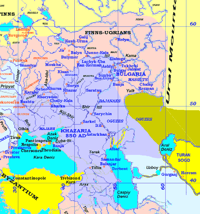
The Khazar Kaganate was a powerful political union formed in the Maritime Dagestan and the eastern Ciscaucasia, in the lower reaches of the Don and the Volga. The landscape of the various parts of the Khazar Kaganate were different. The Khazar Kaganate existed for some 300 years starting from the middle of 7th century to the second half of 10th century. Within the orbit of the Khazars state were not only peoples of the Caucasus but also other numerous tribes - Alans, Bulgars, Burtas. Now the remains of more than 3000 sites of these tribes can be identified there, represented by hillforts, long-term settlements, seasonal sites and cemeteries (Kind of a cultural genocide, 3000 archeological monuments ploughed over by relocated colonist peasants, first with wooden ploughshares, and last in kolkhozes on industrial scale with tractors, to destroy any traces of previous ownership and habitation - Translator's Note). In the middle of the 8th century a significant block of the territory in the forest-steppe zone of the Middle Don Basin was occupied by the Burtas (Türk. Burt-As, "Bee-hive As" - Translator's Note). The sources of the Kievan Rus written almost centuries later called them Yasses, and the Arabic, Persian and Hebrew medieval geographical literature called them Burtas. They migrated to the Don Basin from the foothills of the North Caucasus. The sites created by the Burtas of the Don belong to the Saltovo-Mayak Culture (SMC). Life continued for over some two centuries in the settlements of the SMC territory. The archaeological evidence shows that the Burtas practically disappeared off their territory from the middle of the 10th century, although their name is occasionally mentioned in the narrative sources. The northern frontier of Burtas movement became the Tihaja Sosna river (Don's right tributary), where was built one of the main outposts, the white-stone Mayak hillfort. Throughout the time it became surrounded by a huge village of several hundred huts. This fort was not the single on the Tihaja Sosna river, but the largest one. The Burtas constructed their dwellings in the form of sunken huts. Sometimes near huts they constructed sanctuaries and small family cemeteries. On the slide you can see three excavated huts, sanctuary and several catacomb burials. But most of the burials were in the special burial grounds. A slide shows the beginning of the excavations of a catacomb burial ground near the Mayak settlement. The burial structure consist of an entrance passage and of a burial chamber. Frequently there were paired burials: a man and a woman. Burials of corps were sometimes accompanied by horses with bits, stirrups and other nomadic grave goods. Originally, the settlement area was appraised by the evidence of field-walking. But the trustworthiness of such an approach is disputed because ploughing turned over the cultural layer (or its upper part) and may shift it over very long distances, and sharply change the image of real area of a settlement. The area of Mayak settlement is so large (more then 600,000 m2) that no long-standing excavation and conventional investigation can give an accurate account of its real territory, internal structure and some other essential historical and archaeological features of this unique site. The image computer decoding in laboratory conditions allowed identification of the 30 contrast spots that may mark remains of the medieval dwellings, household and manufacturing constructions hidden nowadays under the soil. A test pit was excavated at the one location. The spot opened a foundation pit of a 3.20 x 3.85 m dwelling cut in the chalky continent surface. After the dwelling was abandoned, a ceramic kiln was mounted in the western wall. Works at another square also were productive. The computer image revealed 14 spots here. A spot 4 was excavated. It was the remains of a household building measured 4.38x3.45 m. |
||||||
2/28/2007