Links
| http://www.transoxiana.org/Eran/Articles/benjamin.html | |
Ērān ud Anērān |
Transoxiana |
|
Mini-Glossary of ethnonyms |
|
Han - Chinese dynasty Hun - aka Hüns, Unns, one of the oldest Türkic endoethnonyms dating back to 2nd millennium BC and recorded from Italy to China, it was also pronounced Sun/Sün/Sön, because of a phenomenon known as a dialectical h/s split. Same people were simultaneously called Huns and Süns and also applied these appellatives to themselves. In the secondary compound ethnonyms, Sün took various dialectical forms of san, sun, zan, shan, djan etc. The basic groups of Hun/Sün people descended into subgroups with adjective discriminators, like Küsün = White Sün, Sünbi = Syanbi = Sünbey = Sün Noble, Jujan = Su-Sün = Water Sün, Sündy = Sinds = Sünnish, Okhondor = Branch Hunnish, Onohundur = Ten Hunnish, Honogur = Onogur = Hunnish Tribe. Kangar - aka Kungur, Qangar, Kenger, Khangar etc., Tr. kang = cart, carriage + ar = people, men, i.e. Carriage People, Wagoneers. Kangar or its variations were endoethnonyms for Besenyos, Sumers, Khwaresmians. Kushan - aka Kusan, Kashan, Kasan, Kazan, Usun, Wusun, Tokhars etc., Tr. ku = pale, white-faced, blond + San = Sun/Sün/Hun, i.e. White Hun. The ethnonym Kushan or its variations were also known for peoples with endoethnonyms of Avar/Awar/Aor, Abdal (Gr. Ephtalites, i.e. Eftals), with a common exoethnonym of White Huns, from Tr. ab = white + ar = people, men. Sai - dialectal for Saka Saka - aka Sak, Sk, a Türkic endoethnonym recorded in the form Sé in Indian and Chinese sources of the 2nd millennium BC and located in C. Asia. In the secondary compound ethnonyms, Sak took various dialectical forms which reached us in the form Sakar = Saka + ar = people, men, i.e. Saka People, Sagadar = Saka + Tr. pl. affix dar, i.e. Sakas, Sogdy or Sogd = Saka + Tr. possessive. affix dy, i.e. Sakian, Sakaliba (Arab) = Saka + Arab. liba, i.e. Saka White, etc. Dialectical variations for the ethnonym Saka are reflected in the toponymy, like Sakastan, Seistan, Scyth - most transparent, but also most mis-exploited ethnonym. Comes from the Greek distortion of endoethnonym Ish-guz or As-guz = As + guz = Tr. tribe, i.e. As Tribe. Ethnonym As reportedly meant nomad, with the same semantics in many other Türkic ethnonyms and their translations, like Iyrk = nomad, Kangar = Carriage People, Gaogüy (Ch.) = High Wheels, etc. Guz is used to indicate a nation, people, tribe, like in Oguz and Unuguz = Ten Tribes, Guz = Tribe, Gagauz = Gaga Tribe, etc Tochar - aka Tokhar, Togar, Dagar, Taur, Togarmah = Tr. Mountaineer, from Tr, Tag/Dag/Tau/Tay = mountain + ar = people, men. Tochars could come from various ethnic backgrounds, but would always be associated with mountains and initially would be referred to by Türkic-speaking neighbors. In Biblical "Togarmah", "mah" is a Hebrew pl. affix. Compound ethnonym with subject As produced synonymic Taulas, with ajective Khas/Kas = Tr. "cliff " produced synonymic Khazar = mountain + ar = people, men. Usun - dialectal pronunciation of Kushan/Kusun. That Kushans and Usuns are related is evidenced by their close ties and mutual assistance, including the merger in the Kushan confederation. An alternate plausible interpretation is As-Sün, As serving as an adjective modifier to the ethnonym Sün. Ku-Süns |
|
Contents |
|
|
Introduction
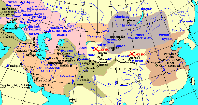
Following the defeat of the formerly powerful Kushan confederation by the Huns near Dunhuang, an oasis on the eastern edge of Taklimakan Desert, in c.162 BCE, the Kushan dynasty and those tribes that remained loyal to it commenced a migration away from the Gansu that was destined to completely reshape the geopolitics of ancient Inner Asia. Both the Han Shu and Shi Ji provide evidence of their departure: "the Kushan had fled furious with the Huns" 1, the 'Kushan had fled and bore a constant grudge against the Huns' 2. The decision to migrate, despite still having a force of perhaps 100,000 armed archer warriors at their disposal is indicative of the severity of the defeat, and also of the steadily increasing power of the Huns under Maotun (209-174) and Ichisye (126-114) during the preceding decades. The Kushan dynasty may in fact have considered such a move several times during the fourteen years between Maotun's initial raid against them in 176, and their ultimate defeat in 162.
Indeed, the fact that the migration seems to have been conducted in an orderly fashion suggests something of a planned strategic relocation rather than a rout. The Kushan's original intention was to move some 2,000 kilometers to the northwest and resettle in the valley of the Ili River, a region occupied by a group of Sakas (or Scythians). They had no intention, nor any idea, that this journey would only be the first stage of a migration that ultimately would take them half away across Central Asia, until thirty years later they would find themselves in secure occupation of the fertile river valleys north of the Amu Darya (aka Cheyhun, Jeyhun, Jaxartes, Yaxartes), and masters of the former Greek kingdom of Bactria.
After leaving the Gansu in 162, the Kushans headed northwest towards the Ili Valley, settling near Issyk Kül in present-day Kazakhstan. Corroborative evidence for this new location is provided by the Greek geographer Ptolemy who mentions a group called the Tagouraioi (clearly a variation on Tocharian, the language spoken by the core Kushans) dwelling near Issyk Kül 3. Russian archaeologist Ü.Zadneprovsky noted a substantial number of catacomb sites in the region, which he has tentatively identified as Kushan on the basis of their similarity to other catacomb tombs discovered at the Haladun site near Minqin in the Central Gansu, which he also argues are Kushan. The Issyk Kül region is rich in nomadic burial sites and some 370 tombs had been noted by as early as 1960. Of these, 80% were in pits, and attributed to the autonomous Sakas, and 17% in catacombs, tentatively attributable to the Kushan 4.
The Chinese sources show that the Ili/Issyk Kül region was already populated by the eastern concentration of Saka or Scythian people. Upon arriving at the Ili, Kushans quickly displaced them: (The Kushans) 'attacked the king of the Sai (who) moved a considerable distance to the south and the Kushans then occupied their lands' 5. Most of the displaced Sakas subsequently undertook their own substantial migration, moving west and then south through the western Tarim Basin, crossing the so-called 'Suspended Crossing' (probably the Khunjerab Pass or similar, between present-day E.Turkestan and northern Pakistan) before ultimately settling in Kashmir 6.
The Kushan confederation occupied the former Sakan lands in the hope of permanently resettling there, and remained in residence for almost three decades (ca. 162-132). They no doubt felt they had successfully relocated, escaping the Huns' menace and reestablishing themselves in the fertile Ili Valley. They returned to their previous semi-nomadic, semi-sedentary way of life and probably began to lose interest in the Chinese/nomadic politics. But the Khan Mo of the Usuns, the former neighbors of the Kushan in the Gansu, could not forget the ill treatment of his people suffered as a result of the Kushan's attack upon them in 173 7. Eventually he sought permission from his Huns overlord (the new Khan Junchen, successor to Jiju who died in 158) to pursue the Kushans into the Ili and 'avenge his father's wrongs' 8. In 132 BCE the Khan Mo led a powerful force of mounted Usun archers into the region, who attacked and routed the undoubtedly surprised and dismayed Kushans, forcing them to once again uproot and resume their long march to the west.
The sources indicate that within a short space of time the Kushans passed through the Fergana region. 'The Kushans thereupon went far away, passing Fergana and proceeding west' 9 and then through a land to the southwest called Kangar. Although the exact route remains a matter of some conjecture, the evidence of both the Chinese annals, and of Central Asian archaeology, leaves little doubt that Dayuan, through which the migrating horde passed, can only be identified with the Fergana Valley 10. The Kushans apparently met with little resistance from the urbanized Ferganese, and after perhaps spending some months (the winter of 132/1?) in southwestern Fergana, they passed on unmolested. Zadneprovsky noted several single catacomb burials that were unearthed in the southwestern, northern and eastern parts of the Fergana Valley, most concentrated in the Lyailyaka-Isfara-Sokha interfluve in the southern Kyrgyzstan, where over 300 catacomb burials were located. Zadneprovsky attributs them to the migrating Kushans, on the basis of their similarity to the catacomb sites also tentatively attributable to the Kushans in both the Gansu and Issyk Kül region 11.
Perhaps in the spring of 131 BCE then, the Kushans most probably moved from the Fergana into the 'state' of Kangar, probably the Zeravshan Valley in the heart of Sogdia. Some four or five years later they were followed through the region by the Han's envoy Zhang Qian, who was led there by guides and interpreters provided for him by the king of Fergana. It is references to Kangar in the Han Shu and Shi Ji (and by Ptolemy in his Geographica), as well as the discoveries of archaeologists, which provided evidence identifying Kangar with the Sogdia, and thus of the role of Sogdia in both the migration of the Kushans and the mission of Zhang Qian. Between the Kangar and Kushan dynasties developed a relationship that subsequently evolved to provide throughout the Kushan Era a vital political and military stability in the region. The evidence that allows for the conclusive identification of Kangar as Sogdia is below [1].
Although several words and even whole sentences in both the Han Shu and Shi Ji are missing, the information provided is still in the same order as that for the other 'western states', so that any gaps cannot be substantial. The distances between Xian and Beitian are not quite reconciled, and the distance from Beitian and the king's summer capital (9104 li or 3641 kms) is surely corrupt, and Pelliot noted Wang Kuowei's suggestion of 1104 li (441 kms) 18 which is a more viable figure within a country described as 'small'. The distance between Beitian and (Le)yueni(di) is described as 'seven days on horseback' in the Han Shu, which Hulsewe and Loewe suggest equals about 500 li i.e. marches of seventy li or 28 kilometres per day through the mountainous country of the region 21. The identification of these two principal settlements with Samarkand and Bukhara is one obvious possibility, although the distance between the two cities by road is about 200 or so kilometres which does not reconcile with any of the given statistics.
A.K. Narain offers a precise geographical location for Kangar: 'the northeastern wedge of modern Uzbekistan into Kirghiziya and Kazakhstan; the eastern part of this wedge formed part of Fergana' 23. This description, however, does not allow for the inclusion of any lands south of the Syr Darya (aka Seyhun, Oxus), thus excluding the entire Zeravshan Valley, the cultural heart and population centre of Sogdia.
The information provided by the texts is hardly ambiguous, however, and clearly suggests the identification of the 'state' of Kangar with ancient Sogdia. Kangar is to the north of the Amu Darya and the Kushan's principal city of Jianshi (Khalchayan in the Surkhan Darya valley?); to the west and northwest of the Fergana Valley (where it also apparently adjoined the clearly very substantial, post-132 realm of the Usun); and southeast of the western realms of the Huns (which must therefore have included the steppes of present-day Kazakhstan). Kangar incorporated lands on either side of the middle Syr Darya, particularly the densely occupied Zeravshan Valley south of the Syr Darya, and must surely have included Samarkand and Bukhara (as Shishkina also argues below). Hence, according to the textual evidence at least, Kangar can only convincingly be located within the general geographical region of ancient Sogdia.
Population/Size
Households: 120,000 Individuals: 600,000
24
'The country is small' 25
The physical dimensions of the Kangar realm may not have been vast, but the population was substantial, which allowed the ruling dynasty to maintain a formidable military force.
Military Strength
Persons able to bear arms: 120,000
26
'They have 80,000 or 90,000 skilled archer warriors' 27
'(it) is not subject to the Protector General' 28
'In the east (the inhabitants) were constrained to serve the Huns' 29
'It acknowledges nominal sovereignty to (Zurcher translates as 'it is subservient to') 30 the Kushan people in the south and the Huns in the east' 31
'However, Kangar felt that it was separated (from Han) by a long distance, and alone in its arrogance it was not willing to be considered on the same terms as the various other states' 32
'(He Wudi - heard that) to the north, there were (people or places) such as the Da Kushan and Kangar, whose forces were strong; it would be possible to present them with gifts and hold out advantages with which to bring them to court'33
The Chinese were clearly impressed by the strength of Kangar, finding them arrogant and militarily self-confident. The military resources of Kangar (120,000 armed men, 80,000 - 90,000 of which were skilled and presumably mounted archers) were substantial, and would not easily be defeated by the Han. Presumably the ruling Kangar dynasty and its pastoralist allies provided the bulk of the mounted archer warriors, while the sedentised agriculturists of the river valleys could be relied upon to provide the remainder. Eschewing any military option then, Zhang Qian argued instead (in his report to Wudi) that the Kangarans could be persuaded by Han gifts and favours to consider becoming subjects (or at least allies) of the Chinese. In short, Kangar was powerful and remote enough to resist Han attempts to join their tributary confederacy by military means, but was clearly under some sort of sovereignty obligation to both the Kushan and the Huns.
Environment/Ways of life
'The way of life is identical with the Great Kushans' 34
'Its people likewise are nomads and resemble the Kushan in their customs' 35
'In Kangar there are five lesser kings all the five kings are subject to Kangar'36
The last reference clearly indicates that 'Kangar' should be considered both as the Han name of the 'state' (that is the realm or region) of Kangar/Sogdia, but also of the dominant faction or dynasty which was controlling that realm at the time (i.e. the Kangar dynasty). Shishkina agrees, and argues that geo-political changes in Sogdia that became apparent towards the end of the second century BCE must have been as a result of Kangar hegemony:
'The historical situation of the first century BC suggests that these changes were related to the spread of the power of the Kangar, when this dynasty controlled Samarkand and Bukhara' 37
The five lesser kings noted in the Han Shu were probably subordinate tribal groups within the realm of 'greater Kangar', and given that all are listed as having specific 'seats of government' (different to the two principal settlements named as belonging to the Kangar proper), may represent sedentised, agrarian-based 'peoples' living under Kangar hegemony 38
The way of life of the dominant Kangar faction was probably that of semi-nomadic militarized pastoral nomadism, similar to the assessment of the way of life of the Kushans soon after their arrival north of the Amu Darya that Zhang Qian provided to the Han court. If the Kangar state is thus to be identified with ancient Sogdia under Kangar dynastic hegemony, then a brief account of Sogdian history prior to the arrival of the Kushan is required to identify the probable date of the establishment of Kangar power, and also to clarify the archaeological and textual evidence of subsequent Kushan/Kangar interaction.
Sogdian Historical Framework Prior to the Arrival of the Kushans
Between 553 and 550 BCE, Cyrus II (aka Cyaxares, Khuvakhshatra) (r. 559-529), a leader of the Persian Achaemenid family, overthrew Astyages, King of the Medes, and brought Mesopotamia, Parthia and Anatolia under his control. By 539 he conquered Bactria and much of Sogdia as well, where he established a line of fortresses on the Syr Darya. Sogdia was made the thirteenth satrapy of the Achaemenids, and paid tribute to the Cyrus' successors. The oldest layers of Afrasiab, the ancient site of Samarkand, date from this Achaemenid period. But the city states of Sogdia and Bactria remained intent upon regaining their independence, which parts of Sogdia may have done by c. 400 BCE 39.
Some two centuries after Cyrus' death, Alexander of Macedon re-conquered much of Central Asia, following his arrival in Bactria in 329 BCE. Alexander's principal opponent in the region was the Achaemenid ruler Darius' former satrap, Bessus (possibly title Besh-su, "Tr. Head of Army"), who had Darius murdered in modern-day Shahr-I Qumis before proclaiming himself as his successor. Bessus' troops consisted of armored cavalry from Bactria and Sogdia, which, following their defeat at Gaugemela, he took back across the Amu Darya after destroying its bridges. Alexander led his troops on forced marches through the desert, crossed Amu Darya on inflated hide rafts, and confronted his opponents who immediately sued for peace.
Bessus was executed; the Macedonians installed themselves in the satrapal palace at Maracanda (Samarkand) and Sogdia, following some seventy years of independence, found itself incorporated into the new Macedonian Empire. But while Alexander campaigned further north along the Syr Darya, the Sogdians, under the leadership of Spitamenes, rose in his rear and massacred a garrison of Macedonians, inflicting arguably the worst defeat of Alexander's career 40. Over the course of the ensuing eighteen months Alexander gained his revenge by reducing the fortified towns of Sogdia one by one, starting in the Hissar Mountains and moving along the Zaravshan Valley 41.
At the heart of ancient Soghd were the valleys of the Zeravshan and Kashkadarya, and in his vengeful campaign along these densely occupied valleys the Macedonians may have killed up to 120,000 Sogdians 42.
Amongst the many prisoners captured during the Sogdian campaign was the Princess Roxanne, daughter of another Sogdian opponent, Oxyartes (probably, Ak-Sir, Tr. "White Sir", Sirs = Kipchaks). Alexander's subsequent decision to marry Roxanne was due partly to her exceptional beauty, but was also intended as a gesture to appease the rebellious Sogdians. After Alexander's death in Babylon in 323, Bactria and Sogdia immediately rebelled but were reconquered in c. 305 by his successor Seleucus Nicator (r. 311-281 BCE). However under Seleucus' son Antiochus I (r. 281-261), Bactria and (probably) Sogdia broke away again from Seleucid hegemony. None the less, Sogdia, along with much of Central Asia, was brought into the orbit of Hellenistic influence during its brief period of Macedonian conquest.
Antiochus I minted an extensive local coinage in the region, probably at Balkh (the 'capital' of Bactria). These were coins of large denominations: staters, tetradrachms and drachms. During the last two centuries before the Common Era, several series of diverse denominations and types were struck at Sogdian mints, and coins were widely used in Sogdia and Bactria, although perhaps only by the Greek population 43
None the less the native population of Sogdia became used to Greek coinage during the Seleucid period, and when the inflow of Greek coins stopped following their independence from Antiochus I, local rulers began to mint their own. As Nymark has pointed out, however, these local issues were highly debased, and in fact were 'mere imitations of the most widespread Greek coins' 44.
Yet these imitations remain as crucial (and often the only) evidence of political, economic and social developments in Sogdia during the first century BCE. Furthermore, both Sogdian and Bactrian imitation issues also constitute potential evidence for the Kushans during the 'five- yabghu period'.
In the mid-third century (c. 250) the Seleucid Governor of Bactria, Diodotus, established an independent Graeco-Bactrian kingdom, which may also have exercised a degree of control over Sogdia. In c. 230 Diodotus' son was overthrown by one of his satraps, a Greek settler called Euthydemus, who then ruled Graeco-Bactria for about forty years until c. 190 BCE. If Sogdia was indeed part of the incipient Graeco-Bactrian state, then the evidence of the Euthydemus imitation coinage indicates that some time late in the third century, during the lifetime of Euthydemus, Sogdia became an independent entity once more 45.
Euthydemus concluded a peace treaty with the Seleucid ruler Antiochus III in 206, but did not attempt to re-conquer Sogdia. Instead the Graeco-Bactrians expanded south into India, establishing the Indo-Greek kingdoms. If the 'state' of Kangar is indeed to be identified as Sogdia, then it was during this period of post-Seleucid independence, i.e. from c. 210 BCE, that the region came under the hegemony of the Kangar dynasty, which then continued to rule an independent Sogdia until it came under Kushan political influence early in the first century CE. As Bopearachchi concludes, under the Kangar dynasty 'Sogdiana probably remained free at least until the arrival of the Kushan in c. 130 BC' 46.
The Passage of the Kushan through Kangar/Sogdia
Although neither of the Chinese sources categorically states that the Kushan horde passed through Kangar, the only logical inference to be drawn from the texts is that they did. In addition, Ptolemy continued to unknowingly chart the course of the Kushan migration by noting a group he this time called the Tachoroi (surely another variant of Tocharian) dwelling in Sogdia 47 (Tr. Tau-ar, i.e. "Mountain People", a good generic exoethnonym suitable for the mountain terrain of the area).
The conclusion that the Kushans must have passed through the region is further strengthened by the fact that the Han sources unequivocally show that Zhang Qian passed through Kangar during his search for the Kushans. The Han envoy was obviously well informed by the rulers of Fergana, who provided him with guides to lead him to the Kushans, about the route followed by the Kushans. And thus the Han envoy likely followed closely in the original footsteps of his quarry. The chronology is straightforward enough.
C. 132/1 BCE: The Kushan depart Fergana and continue their migration to the west
That the Kushan continued westwards in their migration following their passage through (and possibly winter residency in) Fergana is implicit in the key Han Shu passage: 'passing Dayuan (and) proceeding west to subjugate Daxia' 48.
There are three feasible route options west from Fergana, whether starting from present-day Kukon in the centre of the valley, or Isfara in the southwest. The first is due north and then west, across the 2,267 meter Kamcik Pass and through Angren into Tashkent, thence southwest to Samarkand. A second and more direct route is due west through present-day Chugand and Zizzach, thence southwest into Samarkand. However, given that the Zeravshan Valley was the agricultural and population heartland of Sogdia/Kangar (information probably given to the Kushan by the rulers of Fergana who were no doubt anxious to encourage the Kushan to move on and seek suitable settlement lands elsewhere), the migrating horde may have chosen to follow a third route option from Chugand, south over the 3,378 meter Sahristan Pass, then down into the upper Zeravshan Valley. If the Kushan leadership decided upon this latter route, then it would indeed have been necessary for them to winter in southern Fergana before attempting the crossing of this high pass in the spring.
The Shi Ji also implies this in noting (in Watson's translation) that the Kushan 'moved far to the west, beyond Fergana' 49, which Zurcher reads as: 'They passed through Fergana and to the west of that country' 50. Between Fergana and Bactria lay only Kangar/Sogdia; anyone moving to the west, beyond Fergana (or to the west of that country) and heading for northern Bactria would have to have passed through Sogdia. This probability is then strengthened by the unambiguous statement that Zhang Qian was taken to Kangar by his Fergana guides and interpreters, and from there proceeded directly to the realm of the Da Kushan in northern Bactria.
129/128 BCE: Zhang Qian also passes through Kangar
The Han Shu notes that:
'(the king of Fergana) sent off (Zhang) Qian, providing him with interpreters and guides. He reached Kangar who passed him on to the Great KushanDa ' 51.
Or as Sima Qian puts it:
'The king of Fergana trusted his words and sent him on his way, giving him guides and interpreters to take him to the state of Kangar. From there he was able to make his way to the land of the Great Kushan' 52.
Despite its obvious military strength, Kangar (like Fergana) also apparently facilitated (or at least did not hinder) the passage through its territory of both the migrating Kushan horde in c. 131 and the Han envoy in c. 128 BCE. Given the size of its military resources, Kangar was powerful enough to be not 'easily defeated by Han forces', 53 although it was 'constrained to serve the Huns' in the east, 54 and (later) would acknowledge 'nominal sovereignty' (or even become 'subservient to') the Kushan in the south' 55.
Sakas established hegemony over regions of Bactria both north and south of the Amu Darya that the Kushan were forced to defeat and evict to gain control of the region.
Ultimately there is no suggestion (other than the mention of 'nominal sovereignty') that the Kushans were ever forced to confront the Kangars militarily [2]. If there had been any need for conflict, then given the subsequent history of the region (including the invasion of Sogdia by the Karakhanid Dynasty in the 11th Century, for example), the acceptance of the Kushan suzerainty by the Kangars should more accurately be seen as an example of an all-too-familiar phenomenon in Central Asian history, and the greater military power of pastoral nomadic states over semi-sedentary, irrigation-based city states, whatever the relative size of their forces. Despite the fact that the ruling dynasty of Kangar was probably of a militarized, semi-nomadic ancestry, the bulk of the population was surely sedentised agriculturists.
The evidence might alternatively be interpreted as suggesting that Kangar (both the state and the dynasty) adopted a conciliatory and diplomatic position towards most of its neighbors, even including the migrating Kushan horde. Kangar acknowledged nominal sovereignty (or was subservient) to both the Huns and the Kushan; they also assisted the Chinese by helping (or at least not impeding) Zhang Qian in his attempt to locate Kushan and subsequently even sent a 'royal' son as envoy to the Han Court during the reign of Emperor Zheng. Undoubtedly, like the Usun, Kangar felt that the Han court was remote and refused to become subject to the Protector General, but the dynasty was careful to offend no one Han, Huns or Kushan. It is therefore more likely that the Kangar rulers of Sogdia agreed to allow the Kushans an unmolested passage through their territory, and accepted some form of subservient relationship thereafter to avoid military conflict.
It is not at all necessary to envisage violent military confrontation between the two dynasties, but rather a situation where local rulers recognised that the Kushan were powerful enough to be worth accepting as symbolic overlords. Certainly the later Mongol invasions would show that where cities made peace with the migrating, invading force without offering resistance, they could survive and prosper under the rule of pastoralist conquerors, whereas those who refused were destroyed utterly. The apparent ease with which the Kushan subjugated Bactria (just to the south of and contiguous to Sogdia) a year or so later may also have been a salutary reminder to the Kangar dynasty. And, just as the Ferganas might have suggested the Zeravshan Valley in Sogdia as a possible resettlement location for the migrants, the rulers of Sogdia could in turn have nominated the fertile valleys north of the Amu Darya in northern Bactria for the Kushan to relocate, thus discouraging any thoughts the latter might have entertained of remaining in Sogdia itself.
The careful relationship established between the two dynasties in c.131 BCE became an enduring one. Kangar Sogdia would be drawn further and further into the Kushan sphere of influence over the following centuries until substantial portions of its territory may have been incorporated into the Kushan Empire (although this is by no means certain). Certainly, according to the Hou Han Shu, by 83 CE the Kushans were happy to further cement this relationship through an alliance based on a 'bond of royal marriage' with the ruling family of Kangar 57. Even as early as the last three decades of the second century BCE Kangar proved to be an ideal buffer for the Kushan between their new homeland north of the Amu Darya, and the Usun and Huns to the north and east.
The Kangars (or at least some elements of the Sogdian populace) also apparently acknowledged sovereignty to the Huns in the east (presumably northeast), 58 indicating the astonishing reach of Huns' influence. This is confirmed by the Han Shu inclusion of a statement in Zhang Qian's description of the 'state' of Fergana that '(the area) west of Usun as far as Anxi is close to the Huns' 59. That is, Huns influence apparently reached from the steppes of eastern Mongolia to as far west as Parthia. Even allowing for possible Han exaggeration or misinformation, this means that the Huns were in seasonal occupation of (or at least exercised some form of nominal hegemony over) a very substantial western realm indeed, including the steppelands of present-day Kazakhstan and Uzbekistan, from Lake Balkash to the Aral Sea.
It is also possible that this 'nominal sovereignty' took the ambiguous form of gift-giving, which the Huns and Chinese sources interpreted as subordination, but which the locals (including the ruling dynasties of Fergana and Kangar) understood merely as diplomatic courtesies. There is little or no evidence that the Huns actively exercised military power further to the west, although they may have occupied temporary sites along the Middle Syr Darya, if the archaeological evidence of a kurgan at Jaman-Togai attributed to the Huns by the tomb's discoverers in 1968 is accepted 60. Torday is prepared to read this acknowledgment of nominal sovereignty as proof of Huns military subjugation of Kangar, and even attempts to date the beginning of that subjugation from early in the reign of Maotun. He finds the Han Shu passage evidence of 'Kangar's humiliation by Huns in the east', and links this humiliating defeat to a steppe battle conducted by Maotun at Zaysan Nor in 203 BCE 61. Torday's reconstruction is imaginative but without evidence to support it. In the hope of corroborating the textual suggestions of Kushan/Kangar interaction, one must turn to a consideration of archaeological evidence.
Archaeological Evidence of the Kushan in Kangar/Sogdia
Introduction and History
The textual references thus strongly imply that during the latter stages of their migration the Kushan horde probably passed through some regions of the 'state' of Kangar Sogdia. However, as is the case with most aspects of Kushan history, archaeological confirmation of this apparent course of textually-attested events is hardly overwhelming. The most likely location for the discovery of material evidence would surely be somewhere in the valley of the Zeravshan River, which has its source between the Turkestan and Zeravshan ranges in Tajikistan, and then flows west through Samarkand and out into the deserts of Uzbekistan. In ancient times the valley was fertile and sheltered, providing excellent conditions for early Bronze Age agrarian settlements. The discovery in 1976 of the Bronze Age settlement of Sarazm on the upper reaches of the river showed that the valley had been settled for thousands of years, perhaps since as early as the mid-4th Millennium BCE 62.
Archaeological investigation of the middle and lower Zeravshan Valley commenced in 1940 with a survey carried out on the construction site of the Katta-Kurgan reservoir, halfway between Samarkand and Bukhara, which resulted in the discovery of Sogdian kurgans of the 'Kushan period' 63. Between 1945 and 1949 Terenojkin conducted systematic research in the immense town site of ancient Samarkand, Afrasiab 64. This was followed by expeditions from the Uzbek Branch of the Soviet Academy of Sciences in the late 50s and early 60s, which thoroughly investigated a series of sites around Samarkand 65. In 1946, meanwhile, the Academy of Sciences of the Tajik Republic began investigating the upper reaches of the Zeravshan, east of Samarkand, which, under the direction of Yakubovsky, laid the ground work for a systematic archaeological survey of the entire length of the upper regions of the valley 66. Yakubovsky's preliminary work was carried on through the 1960s by Mandleshtam in particular, who discovered numerous kurgans and settlements, many of them apparently left by migrating nomadic groups during the early Kushan era (period between second century BCE and late second/early third century CE in the Soviet archaeologists' lingo) 67. However, within this broad and general chronology the attribution of particular types of burial structures and fortified settlements to specific groups of pastoral nomads was again very difficult. Mandleshtam was the first to attempt to somewhat narrow down the search in his address to the 1968 conference on Kushans in Dushanbe:
'The dating of the investigated monuments (which is substantiated by the results of recent excavations of town-sites) enables us to state with certainty that they belonged to the nomads, who in the last third of the second century BC destroyed the Graeco-Bactrian Empire. Archaeology reveals four groups of nomads, which probably relate to four different tribes' 68.
Obelchenko from 1952 onwards carried out large-scale excavations of nomadic kurgans in the middle and lower Zeravshan, particularly around Bukhara.
Mandleshtam argued that the attribution of all of the kurgans as Sarmatian was too generalised and superficial, particularly as various groups of burials displayed quite distinctively different characteristics.
'The culture of all kurgans exhibits traits resembling the culture of the Sarmat tribes, but this is mainly a 'temporal' resemblance, which is observed over a vast area. A more concrete comparison points to links with areas to the N and NE of Central Asia' 71.
Zadneprovsky also disagrees with Obolchenko, 72 and has argued that similarities between possible Kushan tombs in northern Bactria and those discovered in the Bukharan oasis by Obelchenko suggest that the latter are also relics of the passage of the Kushan through Sogdia:
'The coincidence of the design, funeral ceremony and the accompanying inventory definitely point to their similarity' 73.
Artifacts from Nomadic Tombs in Fergana and Sogdia
A detailed analysis of the 'accompanying inventory' of grave goods discovered at the various nomadic tomb sites does not clarify the matter 74. Pottery vessels (including censers) occur in all types of graves, as would be expected. Gorbunova argues that 'they have a strictly local character, originating in the pottery centers nearest to the cattle-breeding people's area of habitation, or being diffused only over the local area' 75. Thus jugs (with and without handles) are common to the whole region, although they vary in shape from one location to the next. Bactrian and Sogdian jugs and goblets were almost all fashioned on a potter's wheel, which differentiates them from Khorezmian ceramics, for example.
Weapons have also been discovered in most nomadic cemeteries throughout Central Asia, including swords, daggers, iron arrowheads and fragments from composite bows, all weapons generally associated with militarized nomads. Swords and daggers with a cross hilt are characteristic of both the Sogdian and Bactrian sites, whereas the majority of swords from other areas (i.e. areas probably not visited by the migrating Kushan) do not have cross-hilts, thus allowing for possible identification of the unique Sogdian and Bactrian examples as Kushan. Also characteristic of Bactrian and early Sogdian sites are arrowheads with barbed triangular flanges, which differ markedly from the triangular-flanged, straight-based arrowheads found in Khorezmia, Turkmenia and at Kaunchi culture sites (near Tashkent). The graves of Fergana, emphasizing that region's role throughout the Bronze and Iron Ages as an obvious funnel for all manner of Eurasian nomads, contain arrowheads of almost every type76. The arrowheads discovered at early Kushan sites in Sogdia are similar to those found at Begram in Bactria, thus dating them to the 'late-Kushan/early Kushan period' 77.
Household objects, including knives, spindle-whorls and a variety of toilet-articles also demonstrate considerable local variation. Bronze mirrors have been found at sites all over former Soviet Central Asia, with Khorezmia, Sogdia and Bactria yielding mirrors of a similar so-called 'Sarmatian' type, and Fergana again yielding the largest number and greatest variety of examples 78.
Belt buckles have also been found in extensive numbers, indicating that most pastoral nomads probably wore belts with buckles. Differentiation of buckle types is also a potential source of tomb identification. The link between Sogdian and Bactrian sites is again apparent Gorbunova notes that 'belt buckles from Bactrian and early Sogdian cemeteries are obviously of the same kind, and differ from the buckles of other places' 79. The nomadic cultures associated with the different tomb types thus display a series of distinctive individual traits through their material possessions, but also a range of other features commonly shared between all nomadic 'peoples', which increases the difficulties of definitive attribution. Undeniably there is substantial evidence of nomadic passage along (and even temporary occupation of) various sites in the Zeravshan Valley, and it remains a matter of ongoing interpretation as to which tombs and funerary objects (if any) might be convincingly identifiable as Kushan.
Shishkina argues, perhaps too dismissively, that there is no evidence whatsoever of Kushan influence, although her conclusion that the densely populated Zeravshan valley proved ultimately unsuitable as a possible relocation site for the nomads is self-evidently correct:
'In the second century BC the area between the Amu Darya and the Syr Darya was the object of a massive invasion by peoples of a foreign culture, of which tribes of the Great Kushan made up a considerable part. Nevertheless the character of the Hellenized culture was preserved and there are no traces of new influences. One may assume that Kushans passed through Zeravshan Valley peacefully and did not remain there for long. There certainly would not have been enough room in the densely populated and cultivated lands of Soghd for masses of migratory peoples' 80.
Shishkina's claim that there is 'no trace' of the passage of the nomads obviously takes no account of Zadneprovsky's argument that significant numbers of catacomb tomb types, similar in style and design to those found in other areas of probable Kushan occupation (the Gansu, Issyk Kül and Fergana), have also been unearthed along the Zeravshan. Furthermore, in addition to the similarity of tomb-type, many of the artifacts discovered in catacomb tombs also display a range of common features, particularly those found in tombs in Sogdia and Bactria; Gorbunova notes similarities between 'Bactrian and early Sogdian cemeteries with their distinctive types of pottery, weapons, belt buckles and women's clothing' 81. Whilst it is clearly impossible to prove that these tombs and their artifacts were left along the Zeravshan by the migrating Kushan, there is certainly sufficient evidence to at least entertain the possibility.
'Sogdian' Statuettes
Further archaeological evidence of Kushan activity in Sogdia might be provided by the attribution of a particular sub-group of Sogdian statuettes unearthed at several sites in and around Samarkand, particularly at Tali Barzu south of the city, and also at Afrasiab. A form type of female statuette discovered at these (and other nearby) sites, characterized by the position of the hands under the breasts or resting on the upper stomach, and with distinctive facial features and dress, has been analyzed by Fiona Kidd of Sydney University 82. The primary focus group of figurines is distinct and stable in form a female figure with small protruding breasts and very slim arms bent sharply at the elbows so that her hands are resting on her upper stomach. Related groups include statuettes with stumps instead of arms, or with arms resting on the lower rather than upper stomach. The three groups are united by their similar style of facial features. As a stylistic form, similar examples are known from Mesopotamia at least as early as the 2nd Millennium BCE, although it has been suggested that the form probably dates much further back into antiquity 83.
Where there might be some (admittedly very tenuous) link between a particular sub-type of these figurines and the Kushan is through a comparative coroplastic analysis of costume styles. Examples from the Samarkand area show a variety of clothing styles pleats on the lower part of the dress; a looser dress worn over long trousers with folds falling from the waist; a long pleated dress with pleats falling from the waist; or with pleats falling all the way from the shoulders 84. Abdullaev has tentatively attributed one particular group of figurines clothed in a long dress with a flared lower half to the Kushan during their interim residency of the Zeravshan Valley 85. The identification is somewhat strengthened by the discovery of similarly attired figurines at other Kushan and early Kushan sites, notably Tillya-tepe and Dalverzin-tepe 86.
Sogdia lay at the heart of a network of ancient migration and trade routes, and it is only to be expected that Sogdian art would be subjected to a range of stylistic influences, including those of pastoral nomads, be they steppe- or oasis-dwellers. Kidd argues that 'the nomadic legacy of the peoples living in this region must also be recognized as an important factor in the formation of style in Sogdian art generally' 87. That the Kushan occupied, if only for a relatively brief period, parts of the Zeravshan valley including the greater Samarkand oasis is more than likely, given the cumulative textual and archaeological evidence considered above. The possibility that further evidence of their residency might be found through a coroplastic analysis of the costume of figurines unearthed at probable Kushan sites in the region is thus also worthy of consideration.
Archaeological Evidence: Conclusion
Archaeological evidence for the migrating Kushan confederation in both Sogdia and Fergana is at best inconclusive. Mass migrations of nomadic 'peoples' would hardly be expected to leave a substantial archaeological record anyway, given that they generally did not construct settlements or 'townships' meant to last longer than a winter season. During the long, cold Central Asian winters the dead would be buried beside the encampments, and in the spring the tribes would move on in search of dwelling places. This would surely have been the life way of the Kushan during the short period of forced migration following their eviction from the Ili Basin in c. 133/2 and preceding their arrival in northern Bactria in c. 130 BCE. Thus the only record of their passage through the Fergana and Zeravshan valleys would be their funerary monuments and the grave goods they contained. The incidence of catacomb tombs in both regions (mostly with a common north-south orientation), the similarity of household objects, weapons, arrowheads and belt buckles in those tombs, and the possible evidence of Sogdian statuettes, provides clearly circumstantial but arguably cumulatively convincing evidence that there does indeed exist a material record of the passage of the Kushans. Textual and archaeological evidence thus allows for the following tentative narrative reconstruction of events.
Conclusion and Summary
As a result of their defeat by the Usuns in 133/2 BCE, and after almost three decades of residency in the Ili Valley, the Great Kushan confederation was forced to resume its migration westwards, moving initially into the Fergana Valley. Here they possibly briefly occupied sites in the Isfara region before continuing their journey (in the spring of 132/1?), traveling west and south into the Zeravshan valley of Sogdia, before perhaps following it into the Samarkand and Bukharan oases. This itinerary is implied by several references in the Han Shu and Shi Ji, and also tentatively reinforced by Central Asian archaeology.
In the penultimate stage of their journey, Kushan horde entered the realm of Kangar, a dynasty in control of a region most probably identifiable as Sogdia and Zeravshan Valley. 'Kangar' was the Han name for both the 'state' and the powerful ruling dynasty, which may have been in control of Sogdia since it gained independence from the Graeco-Bactrians late in the third century BCE, during the reign of Euthydemus. Ptolemy provides incidental evidence of the identification of Kangar with Sogdia, and once again continued to unknowingly chart the course of the Kushan migration by noting a group he called Tachoroi (Tocharians), this time dwelling in Sogdia 88.
Archaeologists unearthed catacomb tombs potentially attributable to the Kushans at the periphery of the Bukharan and Samarkand oases, as well as in the upper valley of the Zeravshan. All are similar in design, funeral ceremony and 'accompanying inventory' of artifacts to other possible Kushan catacomb monuments found in the northern Bactria 89. In addition, the coroplastic analysis of a group of Sogdian statuettes might eventually provide supporting evidence of brief Kushan occupation.
Both the Han Shu and Shi Ji suggest some level of diplomatic interaction between the Kushan and Kangar dynasties prior to the Kushan's arrival in northern Bactria 90. Although Kangar is described as a 'small' country in the Chinese sources, its military strength was substantial, with some 120,000 persons able to bear arms, according to Ban Gu, 91 of which 90,000 were skilled archer warriors according to Sima Qian 92. Unlike Fergana, it was described as powerful enough to be 'not easily defeated by Han forces', 93 but none the less was 'constrained to serve the Huns' in the east, 94 and acknowledged 'nominal sovereignty' (or was 'subservient to') the Kushan in the south' 95.
Kangar displayed obvious ability at inter-state diplomacy by balancing these competing (and essentially opposed) interests recognising the nominal sovereignty over parts of its country by both the Huns and the Kushan, aiding Zhang Qian and subsequent Han envoys, and later sending a Kangar prince as envoy to China. It is therefore probable that the rulers of Kangar agreed to give the Kushans a safe passage through their territory, and accepted some form of subservient relationship to avoid military conflict. The Sogdian dynasty may even encouraged Kushans to settle at the southern extremities of their territory, and suggested the fertile river valleys north of the Amu Darya as an ideal homeland for the migrants.
Eventually over the following decades and centuries the Kangar would be drawn further and further into the Kushan/Kushan realm, until the southern portions of its territory were probably incorporated into the Kushan Empire, or at least into its sphere of influence 96. By 83 CE the Kushans would further cement this relationship through an alliance based on a 'bond of royal marriage' with the ruling family of Kangar 97. Kangar/Sogdia thus proved to be an ideal buffer for the Kushan between their new northern Bactria homeland and the Usuns and Huns realms in the steppes to the north and east. Ultimately, as a result of the generally cooperative relationship apparently established almost immediately between the Kangar and Kushan dynasties in c. 131 BCE, Sogdia went on to become an integral and stable member (through direct incorporation or alliance) of the greater Kushan sphere of influence until the dissolution of the Kushan Empire in the mid-third century of the Common Era.
Craig Benjamin
March 2003
Dr. Craig Benjamin is a Lecturer in History at Macquarie University in
Sydney, Australia. He can be contacted at: craigbenjamin
![[@]](/at.gif) optusnet.com.au
optusnet.com.au
1 HS 61 1B.
2 SJ 123. See B. Watson, Records of the Grand Historian by Sima Qian Han Dynasty II (Revised edtn., Columbia University Press 1993) p. 231.
3 Ptol. Geog. vi, 14, 7-14. Hermann located Ptolemy's Tagouraioi to the north of the 'Alexandrovski Range', north of Issyk Kül, in A. Hermann, Sakai col. 1770-1806', in Pauly Wissowa, Real-Encyclopadedie Der Classischen Alterumewissenschaft, 2e Reihe, Vol I (Stuttgart 1914).
4 Zadneprovsky (1999) op. cit., pp 4-5. See also J.P. Mallory and V.H. Mair The Tarim Mummies (London 2000) pp. 156 and 158.
5 HS 61 4B.
6 On the Hanging Pass see HS 96A 12A/12B; HS 96B 1B; H. Tsuchiya, 'Tracing Ancient Routes in Northern Pakistan', in M. Alram and D.E. Klimburg-Salter, Coins, Art and Chronology (Vienna 1999) pp. 353 ff.; A. Stein, Ancient Khotan (Oxford 1907) pp. 1-46.
7 See HS 61 4B.
8 HS 61 4B.
9 HS 61 1A.
10 See A.K. Narain, The Tokharians (Shillong 2000) p. 36, n. 11 for example.
11 Y.A. Zadneprovsky, 'Migration Paths of the Yueh-chih based on Archaeological Evidence', Circle of Inner Asian Art Newsletter No. 8 (April 1999) p. 5.
12 HS 96A 15B.
13 HS 96 A 17A.
14 SJ 123, Watson p. 234.
15 HS 96B 1B.
16 Ibid.
17 A.F.P. Hulsewe and M.A.N. Loewe, China in Central Asia. The Early Stage: 125 B.C. A.D. 23. An Annotated Translation of Chapters 61 and 96 of the History of the Former Han Dynasty (Leiden 1979) p. 125, n. 299, 2.
18 P. Pelliot, 'L'Edition collective des oeuvres de Wang Kouo-wei', in T'oung Pao 26 (1929) p. 151.
19 See Ibid. p. 150.
20 E.G. Pulleyblank, 'The Consonontal System of Old Chinese', in Asia Major 9 (1962) p. 94; see also L. Torday, Mounted Archers: The Beginnings of Central Asian History (Durham 1997) p. 319 n. 34 for a detailed discussion of the philological link between Kangar and the Jaxartes (Syr Darya).
21 Hulsewe and Loewe op. cit., p. 125, n. 299, 2.
22 E.G. Pulleyblank, 'Chinese and Indo-Europeans', Journal of the Royal Asiatic Society 2 (London 1966) p. 28.
23 Narain (2000) op. cit., pp. 29-30.
24 HS 96A 15B.
25 SJ 123, Watson p. 234.
26 HS 96A 15B.
27 SJ 123, Watson p. 234.
28 HS 96A 15B.
29 Ibid.
30 E. Zurcher, 'The Yueh-chih and Kaniska in the Chinese Sources', in A.L. Basham, ed., Papers on the Date of Kanishka (Leiden 1968) p. 360.
31 SJ 123, Watson p. 234.
32 HS 96A 16A.
33 HS 61 3A.
34 HS 96A 15B.
35 SJ 123, Watson p. 234.
36 HS 96A 17A.
37 G.V. Shishkina, 'Ancient Samarkand: Capital of Soghd', Bulletin of the Asia Institute 8 (1994) p. 90.
38 Hulsewe and Loewe, op. cit., pp. 130-1, ns. 320, 321, 322, 323 and 324 provide comments on attempts to identify the five principal towns of the lesser kings.
39 See R. Frye, The History of Ancient Iran (Munich 1984) p. 141.
40 Arrian, Book Four, 5-7 (1971) op. cit., pp. 208-211 for a description of this defeat.
41 See for example, A.B. Bosworth, Conquest and Empire: The Reign of Alexander the Great (Melbourne 1988) pp. 117, and 109-10.
42 See for example A. Nymark, Culture and Art of Ancient Uzbekistan vol.1 (Moscow 1991) p. 155.
43 See for example E. Rtveladze, The Ancient Coins of Central Asia (Tashkent 1987) p. 46.
44 Nymark op. cit., p. 156.
45 See O. Bopearachchi, 'The Euthydemus Imitation and the Date of Sogdian Independence', Silk Roads Art and Archaeology 2 (1991/2) pp. 11-12; also Rtveladze op. cit., p. 46.
46 Ibid., p. 12.
47 Ptol. Geog. vii, 2, 15; vi, 14, 7-14. See W.W. Tarn, The Greeks in Bactria and India (Cambridge 1938, 2nd edtn. 1951) p. 517; and J.W. McCrindle, Ancient India as Described by Ptolemy (London 1885) p. 281
48 HS 96A 15A.
49 SJ 123, Watson p. 234.
50 SJ 123.3b, trans. E. Zurcher (1968) op. cit., p. 360.
51 HS 61 2A.
52 SJ 123, Watson p. 232.
53 HS 61 3A.
54 HS 96A 15B.
55 HS 96A 15B; and Zurcher (1968) op. cit., p.360.
56 Torday op. cit., p. 301.
57 HHS 77.4a.
58 HS 96A 16A.
59 HS 96A 19A.
60 On the jaman-Togai Huns tomb see A.G. Maximova, M.S. Merschiev, B.I. Vainberg, L.M. Levina, Drevnosti Chardary (Antiquities of Chardara) (Alma-Ata 1968) pp. 175-190.
61 Torday op. cit., pp. 301-2.
62 On Sarazm see A.I. Isakov, 'Sarazm: An Agricultural Centre of Ancient Sogdiana', Bulletin of the Asia Institute 8 (1994) pp. 1 ff.
63 See V.A. Shishkina, 'Arkheologicheskie nablyudeniya na stroitel' stve Katta-Kurganskogo vodokhranilishcha' (Archaeological Observations on the Building Site of the Katta-Kurgan Reservoir) Izvestiya Uzbfil AN SSSR Bulletin of the Uzbek Branch of the USSR Academy of Sciences (1940) No. 10, pp. 19-24.
64 See A.I. Terenojkin, 'Sogd I Chach' (Soghd and Chach) KSIIMK 33 (1950) pp. 152-169; A.I. Terenojkin, 'Roskopki na gorodishche Afrasiabe' (Excavations on the Site of Afrasiab) KSIIMK 36 (1951) pp. 136-140.
65 See V.I. Shishkina, 'Uzbekistanskaya arkheologicheskaya ekspeditsiya AN UzSSR' (The Uzbekistan Archaeological Expedition of the Uzbek Academy of Sciences. Field Work in 1956-1959), IMKUz (Tashkent 1961) pp. 36-43; V.I. Shishkina, Afrasiab sokrovishchnitsa drevnei kultury (Afrasiab Treasury of Ancient Culture) (Tashkent 1966) pp. 8-10.
66 See A.Y. Yakubovsky, 'Itogi rabot Sogdiiko-Tadjikskoi arkheologicheskoi ekspeditsii v 1946-1947 gg' (Results of the Work of the Sogdian-Tajik Archaeological Expedition of 1946-1947) MIA SSR No. 15 (Moscow-Leningrad 1950) pp. 13-28.
67 See for example, A.M.Mandleshtam, 'Mogilnik v s. Zosun verkhovya r. Zeravshan (The Burial Site in Zosun Village, Upper Zeravshan) Izvestia Otdelniya Obshchestvennykh nauk AN Tadj. SSR No. 40 (1965) pp. 29-44.
68 A.M. Mandleshtam, 'Archaeological Data on the Origin and Early History of the Kushans', in Central Asia in the Kushan Period (1970) op. cit., p. 166.
69 See for example O.V. Obelchenko, 'Kuyu-Mazarsky mogil'nik' (The Necropolis of Kuyu-Mazar) Trudy IIA AN Uz. SSR VIII (Tashkent 1956) pp. 205-227; and O.V. Obelchenko, 'Kurgany okolo sel. Khazara' (The Kurgans Near the Village of Khazara) IMKUz (Tashkent 1963) pp. 57-65.
70 N.G. Gorbunova, 'Early Nomadic Pastoral Tribes in Soviet Central Asia during the First Half of the First Millennium A.D.', in G. Seamen, ed., Foundations of Empire: Archaeology and Art of the Eurasian Steppes (Los Angeles 1992) p. 34; and see O.V. Obelchenko, 'Kurgannye mogilniki epokhii Kushan v Bukharskom oazise' (Kurgan Barrows of the Kushan Epoch in the Bukhara Oasis), in Central Asia in the Kushan Period, vol I (Moscow 1974) for a summary of Obelchenko's conclusions.
71 Mandleshtam (1970) op. cit., p. 166.
72 Y.A. Zadneprovsky, History of Central Asian Nomads in the Kushan Period', in Kushan Studies in the U.S.S.R. (Moscow 1970) pp. 148-9.
73 Zadneprovsky (1999) op. cit., p. 5.
74 See Gorbunova (1992) op. cit., pp. 36 ff for a general outline of material artifacts discovered at a range of Central Asian sites.
75 Ibid., p. 36.
76 Ibid., p. 39; and see G. Frumkin, Archaeology in Soviet Central Asia (Leiden 1970) pp. 42 ff, for a detailed summary of Fergana Valley archaeological discoveries, including grave artifacts.
77 See R. Ghirshman, Begram Recherches Archeologiques et Historiques sur les Kouchans (Paris 1946), Plate XXXVI, Nos. BG 290 a and b for excellent photographs of the Begram arrowheads with barbed triangular flanges. At the British Museum in January 2001 Elizabeth Errington was good enough to show me a colour transparency of a similar arrowhead from the Charles Masson collection. See also E. Errington, 'Rediscovering the Collections of Charles Masson', in M. Alram and D.E. Klimburg-Salter, eds., Coins, Art and Chronology. Essays on the pre-Islamic History of the Indo-Iranian Borderlands (Vienna 1999) pp. 207ff.
78 See Gorbunova (1992) op. cit. p. 44, Fig. 5 for a map illustrating the 'Distribution of Mirror Types'.
79 Ibid., p. 41.
80 Shishkina op. cit., pp. 89-90.
81 Gorbunova op. cit., p. 42.
82 Fiona Kidd, 'The Chronology and Style of a Group of Sogdian Statuettes', in C. Benjamin and S. Lieu, eds., Walls and Frontiers in Inner Asian History, Silk Roads Studies VI (Turnhout 2002) pp. 197 ff.
83 P. Ucko, Anthropomorphic Figurines of Predynastic Egypt and Neolithic Crete with Comparative Material from the Prehistoric Near East and Mainland Greece (London 1968). See also M. Gimbutas, The Goddesses and Gods of Old Europe (London 1982) for early examples of similar figurines.
84 Kidd op. cit., pp 197 ff.
85 K. Abdullaev, in R.K. Suleimanov, Drevnii Nakshab: Problemi' Tzivilizatzii Uzbekistana VII v. do N.E. (Tashkent 2000) p. 203.
86 On the Tillya-tepe figurines see V.I. Sarianidi, Khram I Nekropol' Tillyatepe (1989) p. 53 fig. 15 and p. 57 figs. 17, 25 and 70; on the Dalverzin-tepe figurines see K. Abdulaev, 'Portrayal of musicians in Bactrian teracotta figurines', in Information Bulletin 7 (1984) pp. 52-56 figs. 4-5.
87 Kidd op. cit., p. 211.
88 Ptol. Geog. vii, 2, 15; vi, 14, 7-14. See Tarn (1938/1951) op. cit, p. 517; and McCrindle (1885) op. cit., p. 281.
89 Zadneprovsky (1999) op. cit.,p. 5.
90 HS 96A 15B; SJ 123, Watson p. 232.
91 HS 96A 15B.
92 SJ 123, Watson p. 234.
93 HS 61 3A.
94 HS 96A 15B.
95 HS 96A 15B, and Zurcher op. cit.,p. 360.
96 Whether Sogdia/Kangar or Khorezmia were ever actually part of the Kushan Empire is a matter of some conjecture. See, for example, Svend Helms, 'Ancient Chorasmia: The Northern Edge of Central Asia from the 6th Century B.C. to the mid-4th Century A.D., in David Christian and Craig Benjamin (eds.), Worlds of the Silk Roads: Ancient and Modern (Turnhout 1998), pp. 85-6; and S. Helms (in private correspondence) who has argued that Khorezmia at least remained nominally independent.
97 HHS 77.4a.
|
Author's Discourse Notes |
[1] To consider the evidence that allows for the conclusive identification of Kangar as Sogdia.
References to Kangar and the Kushan in the Han Annals
Kangar Sogdia: Location and Lifeway
Location
'The seat of the king's government in winter is in Leyuenidi to the town of Beitian. It is distant by 12,300 li from Xian. One reaches (Le)yuenidi after a journey of seven days on horseback, and it is a distance of 9,104 li within the realm to the king's summer residence. To the east it is a distance of 5,500 li to the Seat of the Protector General' 12.
'It is said: Some 2000 li to the northwest from Kangar is the state of Yancai. The trained bowmen number 100,000. It has the same way of life as Kangar. It is situated on the Great Marsh, which has no further shore and which is presumably the Northern Sea' 13.
'Kangar is situated some 2,000 li northwest of Fergana. The country is small and borders Fergana. It acknowledges nominal sovereignty to the Kushan people in the south and the Huns in the east' 14
'(Usun) adjoins Kangar in the northwest' 15
'(The State of Usun) and 5000 li to the west, to land within the realm of Kangar' 16
Attempts by scholars over several centuries to geographically locate and delineate Kangar have not been helped by textual corruption in both the Han Shu and Shi Ji. And yet, although several words and even whole sentences are missing, the information provided is still in the same order as that for the other 'western states', so that any gaps cannot be substantial. Certainly the distances between Xian and Beitian are not quite reconciled, and the distance from Beitian and the king's summer capital (9104 li or 3641 kms) is surely corrupt. Hulsewe and Loewe suggest that the text may originally have read 'ninety one li' (or 36 kilometres, although this seems too low),17 while Pelliot noted Wang Kuowei's suggestion of 1104 li (441 kms) 18 which is a more viable figure within a country described as 'small'.
The identities of both Beitian and (Le)yueni(di) are almost impossible to determine, however, Wang Kuowei identified the former (impossibly) with Issyk Kül19 while Pulleyblank has argued that the latter might 'represent some form of the name Jaxartes' 20. The distance between Beitian and (Le)yueni(di) is described as 'seven days on horseback' in the Han Shu, which Hulsewe and Loewe suggest equals about 500 li i.e. marches of seventy lior 28 kilometres per day through the mountainous country of the region 21. The identification of these two principal settlements with Samarkand and Bukhara is one obvious possibility, although the distance between the two cities by road is about 200 or so kilometres which does not reconcile with any of the given statistics.
Pulleyblank discusses the possible Tokharian philological origin of the name 'Kangar', in his reconstruction of 'Old Chinese' *khan-kiah. In the Tokharian vocabulary (Tokharian 1A) there is the word kank, which means 'stone'. Thus Kangar could mean the 'Stone Country', i.e. Samarkand (or equally Tashkend as 'Stone City') 22. A.K. Narain offers a precise geographical location for Kangar: 'the northeastern wedge of modern Uzbekistan into Kirghiziya and Kazakhstan; the eastern part of this wedge formed part of Fergana'23. This description, however, does not allow for the inclusion of any lands south of the Syr Darya, thus excluding the entire Zeravshan Valley, the cultural heart and population centre of Sogdia.
[2] Does this acknowledgement suggest that parts of Sogdia (and the most populous parts at the Zeravshan valley and Samarkand) were actually invaded and defeated by the migrating Kushan, and then forced into a subordinate relationship thereafter? Certainly Torday is prepared to argue that not only did the Kushan defeat the Kangar dynasty in Sogdia, but in northern Bactria as well where he suggests the Kangar were also ruling:
'We must accept that they took the region from the Kangar by force, in a war. His (the Kushan king's) subsequent conquest of Sogdiana was probably a by-product of his ambitions further south-east where he had brought Bactria under his sway' 56.
If Torday is correct, this says much about the military capabilities of the migrants that a displaced, previously fragmented and essentially homeless nomadic tribal confederation, soundly defeated twice during the previous three decades by the Huns and the Usun, was none the less able to invade and defeat the well-defended state of independent Kangar Sogdia. But there is simply no evidence to support Torday's reconstruction, and indeed his argument is unconvincing. He has the Kushan settling in the Jaxartes (Syr Darya) delta rather than northern Bactria at the end of their migration, which is clearly incorrect as textual and archaeological evidence indicates. He then suggests that the Kushan defeated the Kangar dynasty to gain control of Bactria, where the evidence shows it was a group of Sakas (who had established hegemony over those regions of Bactria to both the north and south of the Amu Darya) that the Kushan were forced to defeat and evict to gain control of the region.
[3] Obelchenko, however, who from 1952 onwards carried out large-scale excavations of nomadic kurgans in the middle and lower Zeravshan, particularly around Bukhara, linked all of the funerary monuments discovered in the Zeravshan to an invasion of 'Sarmatian' tribes in the second to first centuries BCE 69. Gorbunova has summarised Obelchenko's mid-50s theory thus:
'The discovery and investigation of Sogdian pastoralists' sites were begun by O.V. Obelchenko. He isolated among the cemeteries an earlier group dating from the second century BC to the first century AD, and a later group dating from the second to the fourth centuries AD. He regards both sites as relics of the Sarmatian tribes whose attacks contributed to the final defeat of Graeco-Bactria' 70.
Obelchenko's conclusions were questioned by Mandleshtam, who argued that the attribution of all of the kurgans as Sarmatian was too generalised and superficial, particularly as various groups of burials displayed quite distinctively different characteristics.